


Winds revisit does not disappoint
We drove from home in Idaho to the foot of the Wind River Range (Winds), chased by rainstorms. After a dry summer and spring, boiling black clouds and precipitation were welcome.
But I wasn’t sure about meeting storms in the 12,000-foot Bridger and Popo Agie wildernesses, soaring towers and lake basins along the Continental Divide in western Wyoming. We had planned an 8-day backpack through the iconic range starting just before Labor Day weekend 2025.
Timing was a bit precarious for this multi-purpose trip. After a July-August trek through Idaho and Montana, David wanted one more backpacking trip for our shorter than usual summer/fall hiking season, cut short by my plans to go to Tucson mid-October to prepare for shoulder surgery. (See my blog on previous arthritis challenges.) We had also signed up for September triathlon so small hiking window.
We had wanted to revisit the Winds for some time—we had hiked them at least two or maybe three times when we lived in Utah in the 1980s. Further, this spectacular range was only five hours from home in Idaho and offered good trails and ample water for devising a reasonable trip with minimal planning time.
Labor Day weekend was not the best time to visit this popular alpine area, especially Big Sandy Trailhead—where most backpackers and climbers enter so they can loop around the famous Cirque of the Towers. But we had gone that way on our last recorded trip in 1988. And like everyone, we wanted to see the Cirque again.
We think we first visited Winds in 1980 or 1981. We drove from Utah, backpacked in a few miles to camp by large lake, woke to heavy rain and slogged back out. On drive back home we looked back and saw it clearing over the Wind Rivers! No pictures from that trip.
We have 1988 pictures (check 1988 Aug-Sep visit below) of meeting friends and camping near Cirque then hiking passes, near big lake, and high plains likely Continental Divide Trail (CDT). I recall either another trip or part of that one: high route on flat rocks, meeting backpackers, and hiking near lakes in thick clouds of mosquitos. Among unidentified 1988 photos the 13 “High elevation, unknown locations” may correlate with my memories.
Route for the 2025 revisit was determined by one phone call.
David was hoping for a one-way trek starting at Big Sandy. He called Half Moon Lake Lodge; a reasonable end point a few hiking days north of that trailhead and a few miles from Pinedale.
The manager offered up one of her outfitters to shuttle us to Big Sandy. We would need to be lodge guests (minimum stay two nights). The lodge had availability just after the holiday weekend.
David booked the trip and planned a hiking route that would loop around the Cirque, head north along the Continental Divide Trail, and drop down the lodge’s trail to Half Moon Lake; about 80 miles in eight days.
We visited 2 wilderness areas in the Wind River Range (Winds) running NW-SE in western Wyoming: Bridger and Popo Agie (pronounced puh-POE-shuh in Crow language). The Continental Divide (Divide) follows crest of the range and includes Gannett Peak, at 13,800 feet highest in Wyoming, and more than 30 other peaks higher than 13,000 feet.
Two national forests, Bridger-Teton west of Divide and Shoshone on east, encompass most of the range; part of east side is within the Wind River Indian Reservation. Gannett Peak is in 3rd wilderness area—Fitzpatrick—which we did not visit.
Indigenous peoples have left archeological evidence dating back to 10,000 years ago or longer. Villages as high as 10,000 feet dating from 700-2000 BC were established by Sheepeater band of Shoshone for whitebark pine nut harvest. John Colter from Lewis and Clark expedition possibly visited in 1807. First white visitors were rock climbers in the early 1900s.
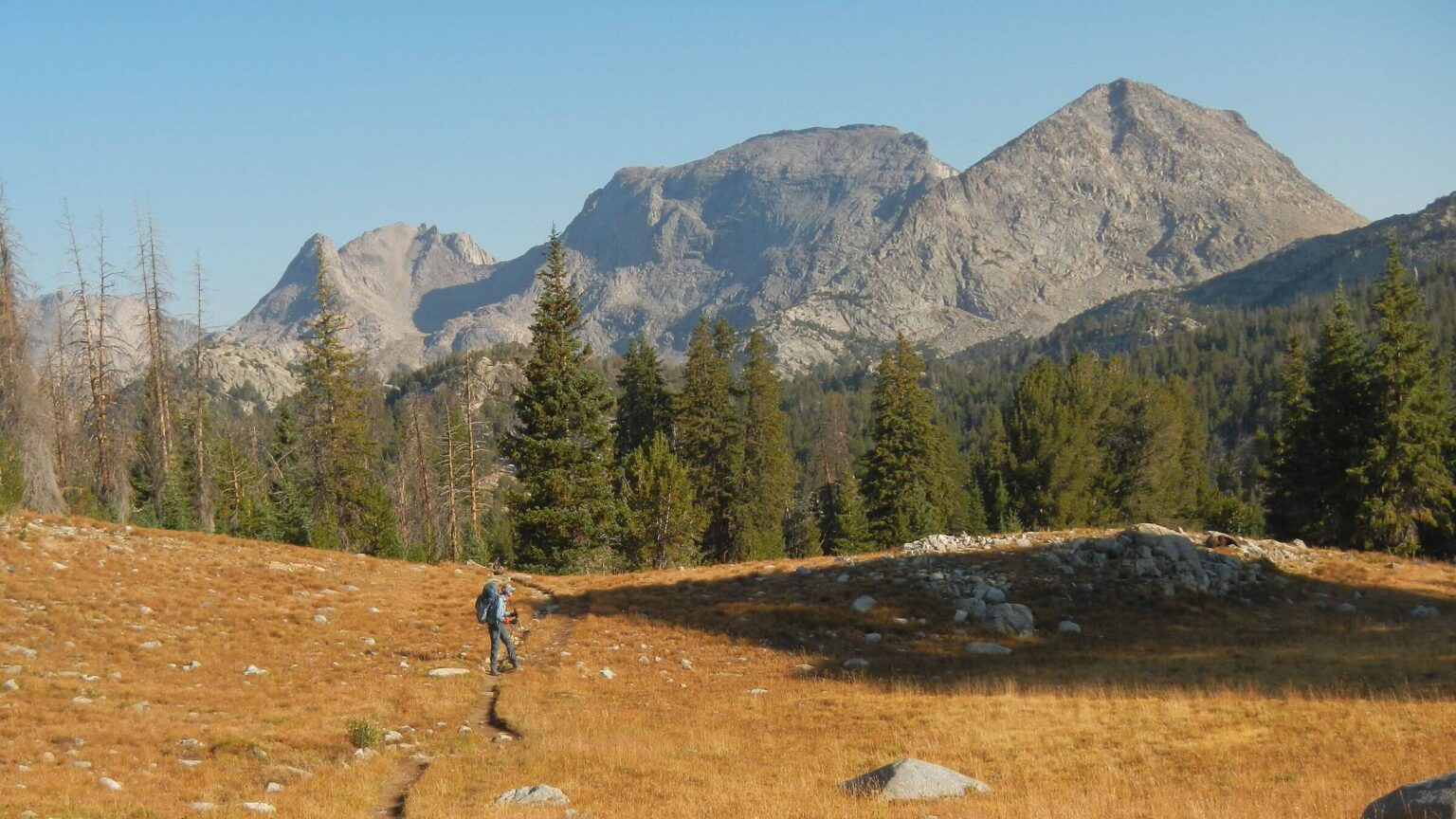
Winds are extremely popular backpacking area, particularly Cirque of the Towers granitic towers circling a glacial valley with Lonesome Lake at their base. Many climbers attempt some of the peaks, and throngs of backpackers come in through Big Sandy Trailhead, looping on both sides of the Divide to pass by the Cirque.
Continental Divide Trail (CDT) follows the Winds for about 100 miles; mostly on west side although alternate route loops through east side by the Cirque.
We spent 8 days in Winds encompassing Labor Day weekend. We hiked from Big Sandy Trailhead to Half Moon Lake Lodge, crossing Jackass, Lizard Head and Washakie passes in Popo Agie Wilderness, then hiking CDT north through Bridger Wilderness. Half Moon Lake Lodge’s outfitter shuttled us to Big Sandy.
We arrived in rain after prolonged drought in Wyoming; other than slick climbing on route above Big Sandy Lake, clouds over Cirque, and cold winds on 12,000-foot Lizard Head Pass, most impact was positive: damp trails and adequate water with blue smoke-free skies after Day2 of our trip.
Fires were not much of a problem in this high elevation area with little contiguous tree fuel. We encountered only two burn scars. There was small 2024 or possibly 2025 burn at Lonesome Lake for which we could find no information, and we crossed eastern edge of 1988 Fayette Fire a couple times (click Fires box on map below). Dollar Lake Fire northwest of our trip route created smoky sky when we first arrived in Pinedale, but rain cleared sky for our trip, even though fire was not contained until October 2025.
Visit statistics: 8 days, 83 mi hiking, at 1.9 mph, with 400 ft/mi of average elevation change.
Go to map below for more information on trailheads, daily routes, mileages, elevation changes, and photos. (Click on white box in upper-right corner to expand map and show legend with NAVIGATION INSTRUCTIONS.)
show more
Locked in for a rain hike
We were already scheduled and booked when forecast called for big storms throughout the West. It had rained off and on for two days in Hailey ID when we left. The storm seemed to follow us to Wyoming, with showers whenever we stopped for meal or break.We stayed in Pinedale for overnight for early trip start. Both of us went for a short “rain jog” around town; it later cleared for a nice walk to dinner at one of the recreation town’s pubs.
Next morning, we drove in heavy rain to Half Moon Lake Lodge. Here we met red-headed Dominic, lodge outfitter who would drop us off at other end of the Winds to backpack our way back to the lodge. After enjoying the breakfast he fixed of flapjacks, bacon, and eggs, we suited up in rain gear and joined him in a king cab pickup truck for a bumpy drive to Big Sandy Trailhead.
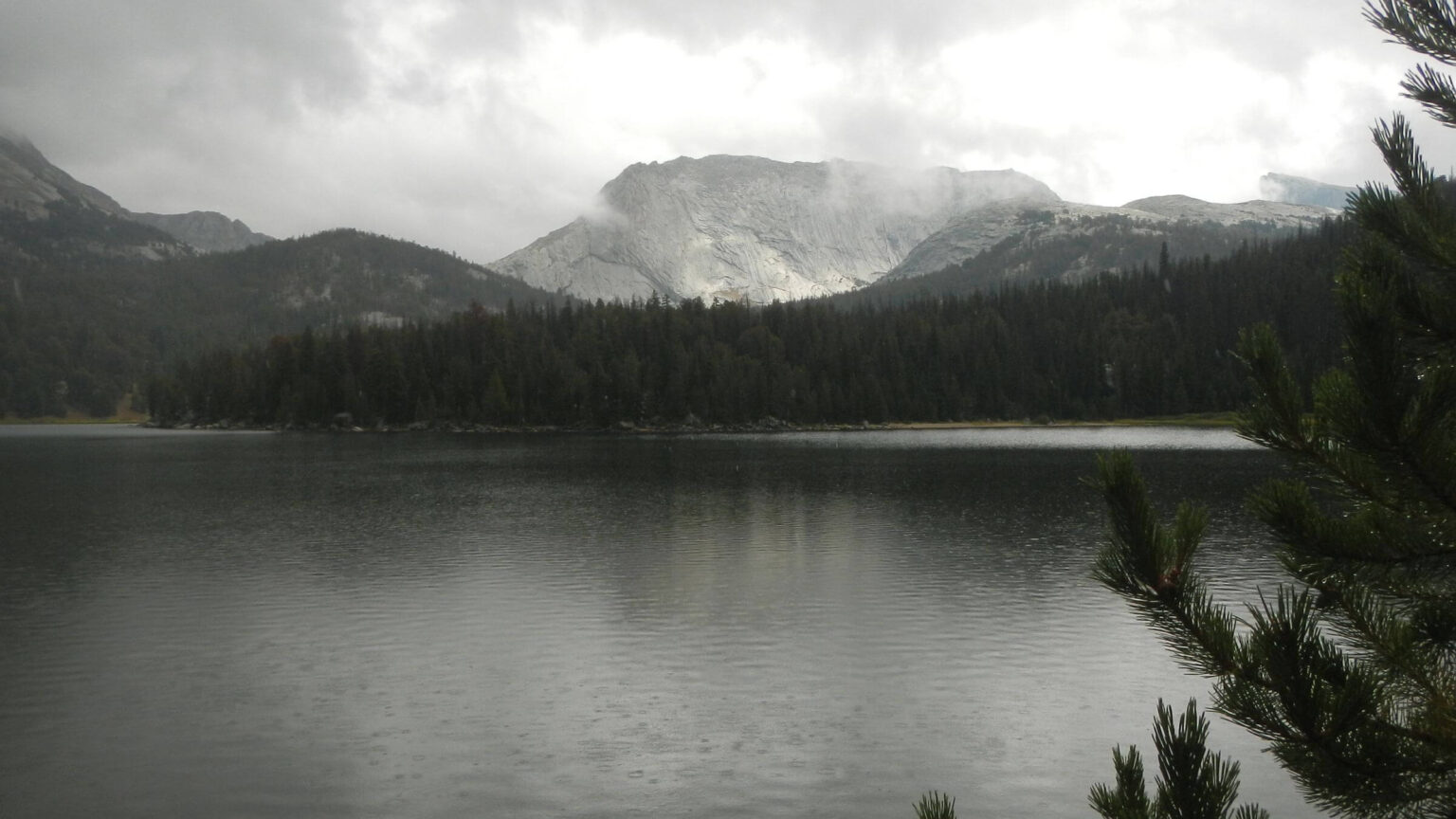
Some 80+ vehicles at the big Bridger Wilderness parking lot, probably most popular trailhead in the Winds with access to the Cirque and also stop along the CDT. Rain had softened to showers as we hiked gentle trail towards Big Sandy Lake. We met many raingear or plastic-clad backpackers returning. Some reported 3 days of rain—the storm system had beat us to Wyoming and taken up residence on high, raining the hardest on east side of the Divide.
Showers diminished and I switched to t-shirt and shorts as warm sun peeked through clouds. We played tag team with a group carrying only light packs; an outfitter from Big Sandy Lake Lodge would set them up to camp at Big Sandy. The cowboy, with string of horses and mules, passed us just before we reached the lake.
Hard rain returned as we started up trail above the lake. After short break in spruce too small for much shelter, we trudged up switchbacks channeling water. Two young women with light packs trouped by us; we met others coming down. Trail became route up slippery scree. After ferrying my backpack down slick boulders to a grassy opening, David suggested we stop for the night at lovely meadow above North Lake by an inlet creek. We had planned camp at Lonesome Lake, another three miles, but he nixed more scree in the rain. Rain quit.
Above us, a backpacker bounced down the rocks and arrived in camp. “Frito” was a south bound (SOBO) CDT hiker taking alternate route by the Cirque (main route is west of the Divide). He said water in Lonesome Lake had E. coli bacteria—just as well we had not pressed on to camp there. Two more groups passed through our camp heading up pass, two other groups came through on way out. Hard rain returned and we took refuge in the tent! Later it cleared and I cooked dinner as sun set, lighting up peaks below us.
Cold winds and happy hikers
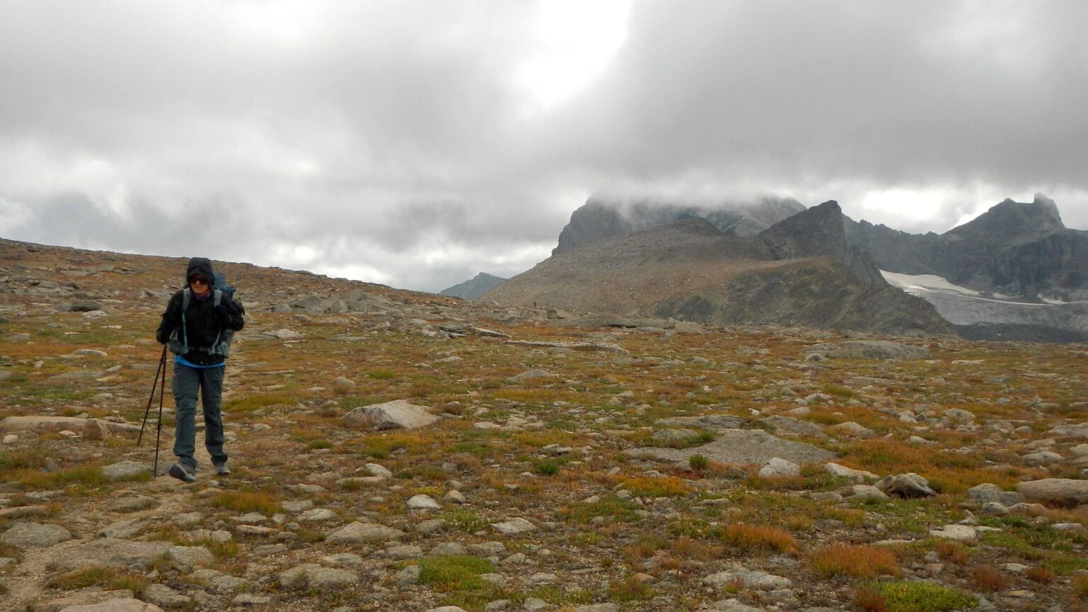
Not much rain on Day2 after early morning; but cold and grey with flitting clouds around Cirque as we passed camps of the people who had passed us, scrambled scree along Arrowhead Lake, climbed Jackass Pass and descended to greenish Lonesome Lake. I saw one tent high in the basin. We met backpackers near pass.After break above Lonesome Lake (we did not use water from the lake or creek below) I had severe foot pain on the mellow trail down North Fork Creek. My new Altra boots had extra lacing grommets that pinched my ankles. David added padding to the boots, first of many stops trying to deal with painful boots.
We met another dozen backpackers coming down steep switchbacks to Lizard Head Pass. Trail climbs to almost 12,000 feet (with sight of gorgeous Bear Lakes below and Lizard Head Peak in clouds) then contours several miles, with views across deep gorge to Continental Divide. Everyone enthused about the views. In the icy wind on top, I was too cold to care. Behind us, a couple with big backpacks (particularly the male) probably toting climbing gear.
The woman probably could have caught us but kept stopping for partner with big pack to catch up. We all stopped for break out of wind on either side of snowbank fed stream to Little Valentine Lake. We had just enough water for break so did not fill up at charming stream.
(David notes that in his hurried planning, he had misread GPS map thinking that Valentine Lake outlet was an “inlet.” As it turned out the snowbank stream for break was uppermost inlet! He had to filter water at Valentine Lake outlet—which apparently caused him some stomach issues the next few days.)
We weren’t sure whether the climber couple camped at the snow fed stream or were the late arrival couple we noticed camping in a site near us at the lake later that evening.
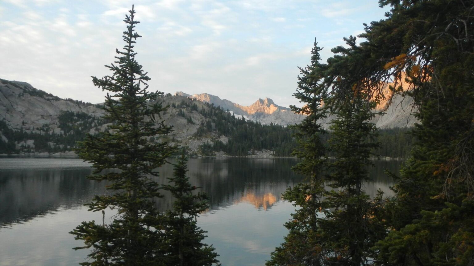
Towering peaks and sunset colors on lovely Valentine Lake and sunny day to ascend Washakie Pass. We passed cheery backpackers drying gear in a meadow and when we stopped for breakfast break by Washakie Lake, were passed by a woman on horseback leading a pack horse. (We had seen horse tracks on the trail down from Lizard Head Pass starting at snow fed stream).
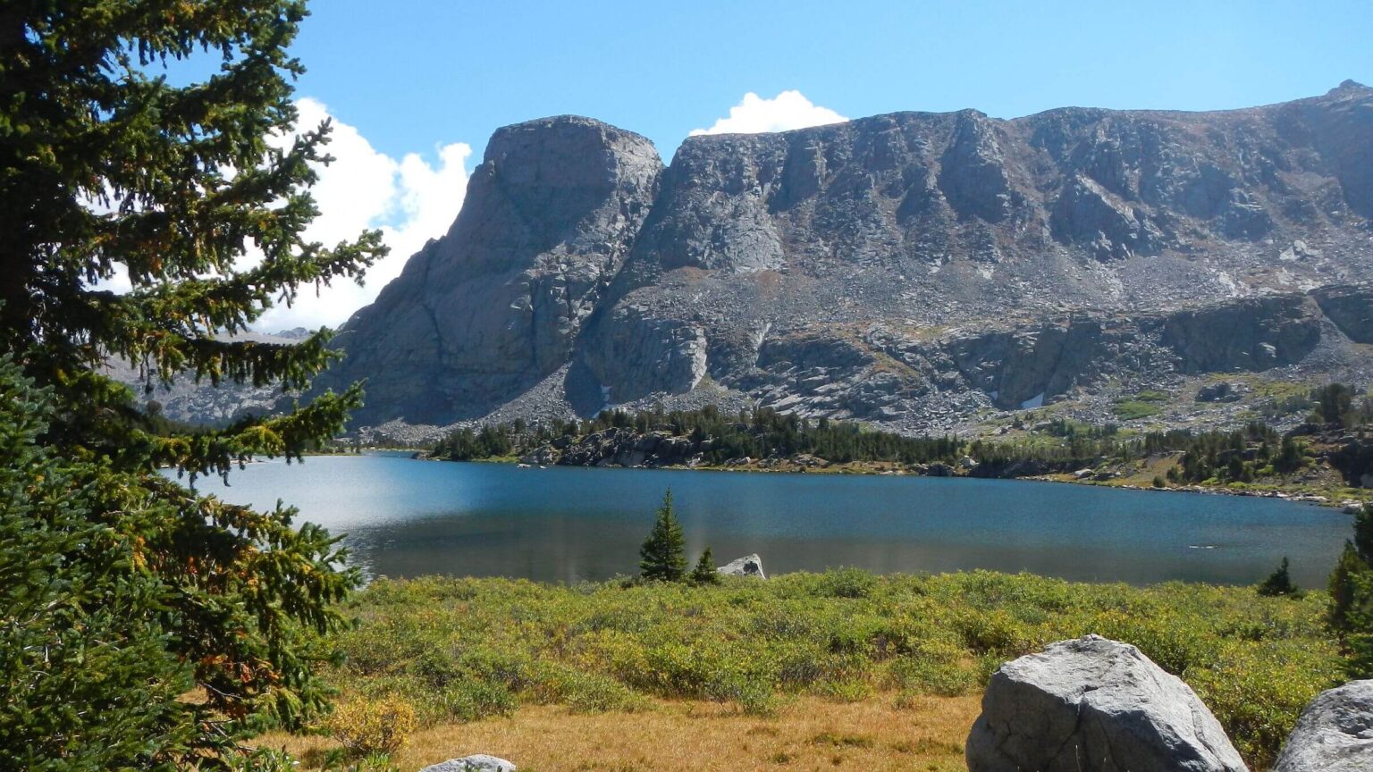
We took break in rocky shelter out of wind just below Washakie pass. Met more folks on other side and joined hordes camped at Skull Lake below. I saw outfitter stopped in a grove with several horses and mules. We took evening hike to Pyramid Lake basin on a very washed-out trail dotted with horse poop indicating outfitter had packed in the big group we saw camped on edge of basin between lakes with giant tents, tables, stoves and three obnoxious small barking dogs.
Another clear day to join Continental Divide Trail meandering down basins, crossing wide Washakie Creek on carefully placed rocks, wading East Fork River (only serious crossing entire trip) near outfitter camp with bored tethered horses, steep climb over a pass, then long trek on plains near large lakes.
Met 3 CDT hikers and were passed by 2 anxious guys with light packs and fishing gear probably on their way out. A feature of the Winds is many side trails and trailheads facilitating short weekend trips. Sad to see cattle grazing on the high meadows along one of the big lakes.
We stopped more than usual—trying new padding arrangements for the troublesome boots and trying to stretch my increasingly achy shoulder. Still, we made our planned miles for each day, aided by well-marked maintained trails.
“Indoor rain” at Raid Creek
We camped at barely running Raid Creek; David nixed camping at big flat Raid Lake another mile up the trail, concerned about wind and lack of trees. Thunderstorms moved in; I made dinner between showers. Break in rain let David burn garbage in a fire circle. Later it rained and hailed hard.It cleared off in the wee hours; our tent froze hard with moisture. In early morning, frost melted and “rained in the tent” soaking bags and clothes! We waited until sun hit the tent to get up, then dried everything on large rocks around camp. Later on the trail, an outfitter and a few riders passed us—out for a trail ride from the camp we passed yesterday near Washakie Creek. I asked about the frost—they had none in the meadow!
Near sprawling Bobs Lake a kid riding bareback rode up and asked if we had seen lost horses. Nope. A woman dropped down from a camp above lake and said the boy and his dad were seeking three of their friends’ horses who had escaped last night. Rounding the lake we saw a rider in cowboy hat (probably dad) leading a string of horses. A cow dog greeted me. Hobbled horses leaping along were probably the escapees! Hiking up and down around big lakes (including Sandpoint Lake—probably after sandy hill toe—with a small beach below!) we met backpackers on short treks, a couple CDT SOBOs (including a lively German girl with trail name “Swampy”) before early camp in pines above lower Pipestem Lake.
Hard freeze next morning, and chilly hike above lake basin. I had hoped to take short day hike up Europe Canyon (which looked intriguing on the map and hikers mentioned it) above Pipestem lakes but never saw the turnoff and was too cold to look for it. Just as well. It was a tough day over 3 rocky passes on CDT; an extra hike would not have been welcome!
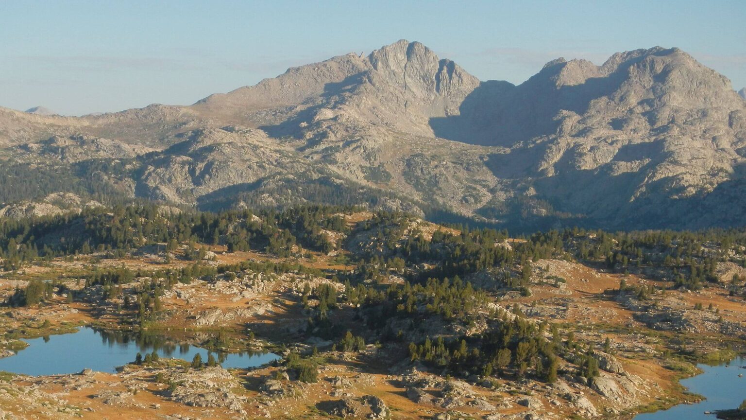
Looking Back to Towers
From high points looking back, the sky-high towers along the Divide were incredibly beautiful. The alpine splendor of long serene lakes, wide plains, rocky passes, and rugged towers of the Wind Rivers can only be told in pictures! We saw a woman with dog camped on large lake, a couple who had looped through interesting side trails I had noticed to lakes and passes and, at day’s end, a cheery SOBO who had spent night in Pinedale, hiked 12 miles in, and planned 4 more.We camped in scruffy trees on a bench along waterfall inlet to Baldy Lakes; I explored washed out trail down to basin, crossing muddy wetlands and brush, but found only sketchy spruce along lake.
Next day well-placed switchbacks offered nicer hiking up another steep pass, then long descent along Baldy Lakes Basin with little lakes and tarns, crossing several springs. We met “Friendly,” a SOBO from East Coast who had done Appalachian Trail and was finishing CDT. He had ‘flip flopped’ and hiked Colorado and New Mexico, now doing Wyoming leg. He thought Winds were highlight of the 3,100-mile trail! He mentioned a CDT alternate, Wind River High Route, partly off-trail crisscrossing the Divide, that intrigued me for a return trip. It sounded like large flat rocks on Divide I recall on earlier trip David disputes.
CDT went north to next pass, but we took trail down Pole Creek to a crossing just before big lake where we washed up (a short ways down the trail we met an embarrassed woman with backpack who maybe saw us and turned back for a bit! We’d been looking for accessible sunny spot on Pole Creek for over mile and crossing seemed to be the last chance.).
Leaving the wilderness
Long contour up along meadows and tarns; somewhere along there David recognized Michael Lanza, former Outside magazine writer and self-styled hiking guru. We exchanged a few words about respective websites.We passed Marys and Two Tops Lakes, descended to Ekland Lake then up to junction of several trails. Following David’s GPS route, we picked most obscure side trail (main trail goes to Elkhart Park trailhead) past Upper Sweeney and Middle Sweeney lakes, then even more sketchy route to camp at Lower Sweeny Lake.
According to David, we were probably taking outfitter’s trail, most direct route to Half Moon Lake, used for hunter clients on horseback. Although our camp above lake in big whitebark pine was nice, the route out was not. I left camp early, missed the route and returned to find David to follow GPS track. Obscure trail through meadows, then climbed up and down several ridges, apparently avoiding small lakes.
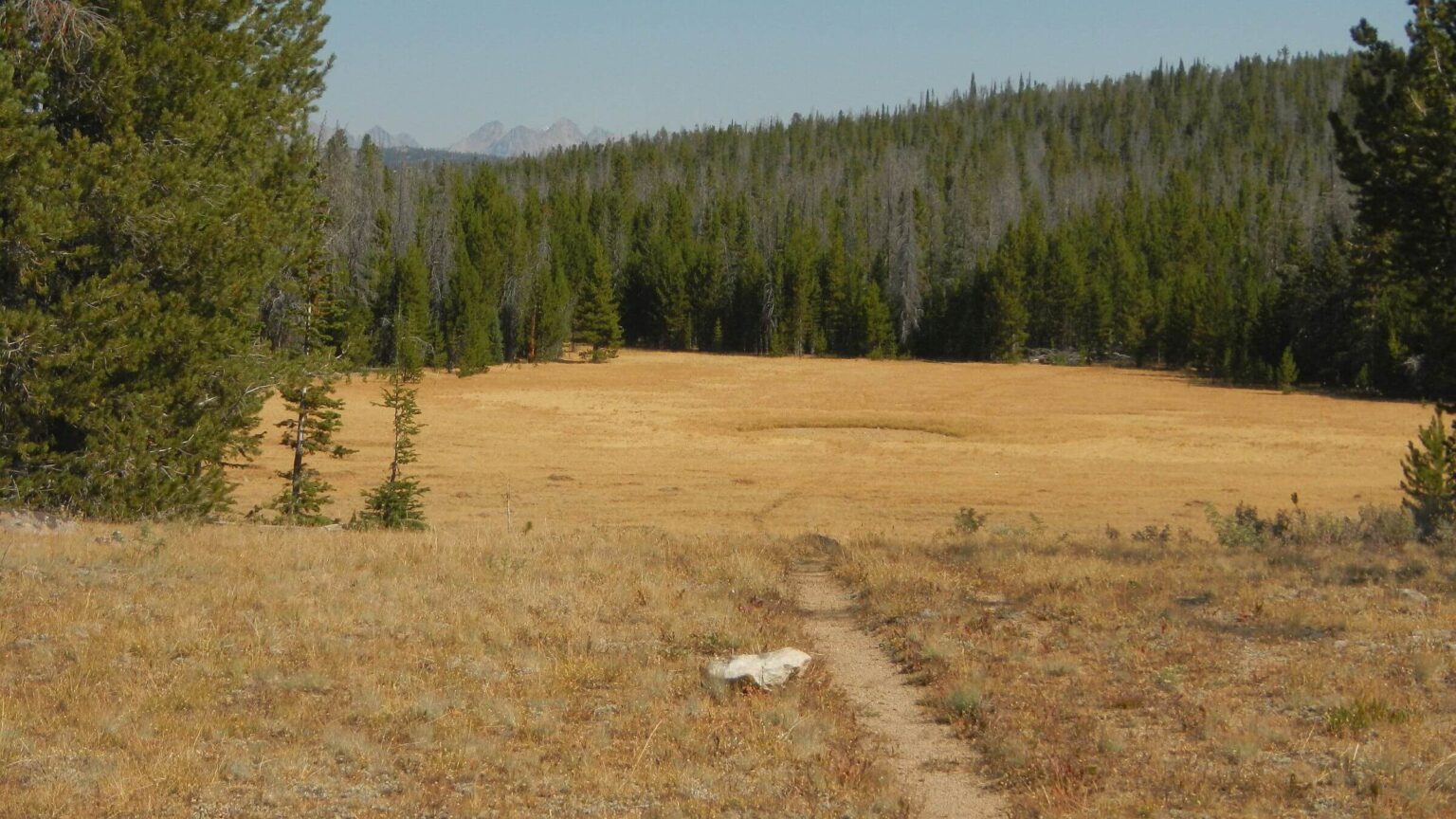
Trail finally descended through woods and large blowdown (that had been well cleared) to cross a big meadow, climb up other side and contour down to a junction. We turned right onto long switchbacks which appeared to be new trail (In retrospect, we were probably confused by ski trail loops in area). At bottom we followed road along sagebrush valley. David noticed best route had missed his GPS track, so we slogged through sagebrush, backtracked up another road and met a steep trail descending a ridge. This contoured down towards Half Moon Lake, made short steep switchbacks on washed out trail, descended more gently through aspen forest, then plunged to a gate and a pond. I felt sorry for anyone on horseback using this trail! I later learned there was an alternate route.
Here were the highest cabins for Half Moon Lake Lodge. We dropped our backpacks and walked the long road for check-in at the lodge where we had reservations for two nights. Backpacking was done and “rest” had begun.
show less
Google Map
(Click upper-right box above map to “view larger map” and see legend including NAVIGATION INSTRUCTIONS; expand/contract legend by clicking right arrow down/up.)