 Aravaipa Creek perennial stream in desert (Day1)
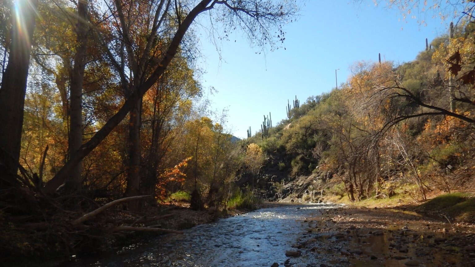 Aravaipa Creek was running at about half-foot depth (Day1)
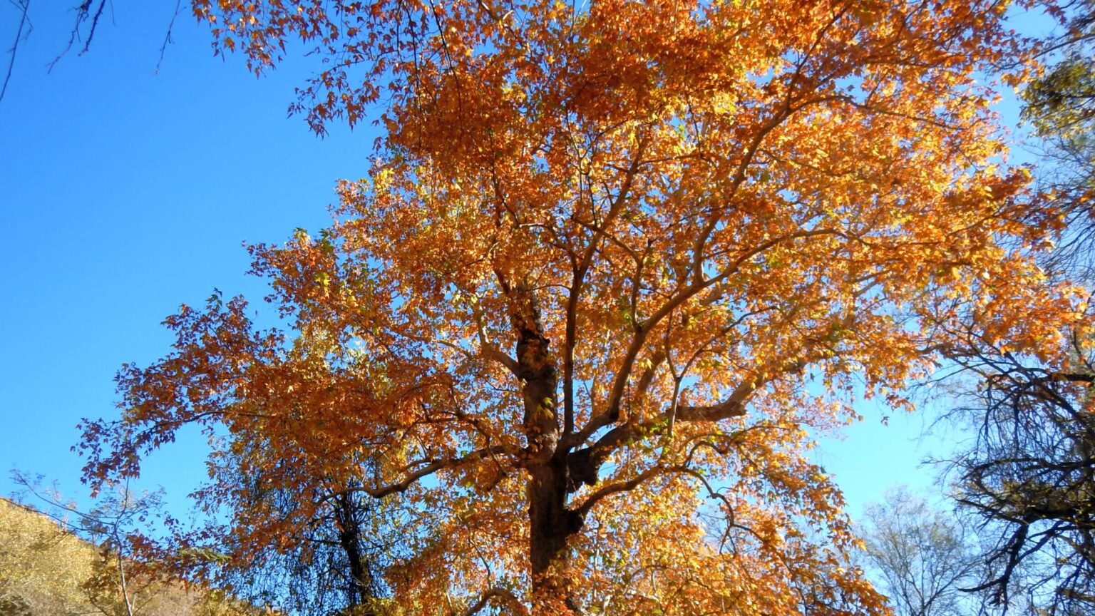 Arizona sycamore was most brilliant fall color (Day1)
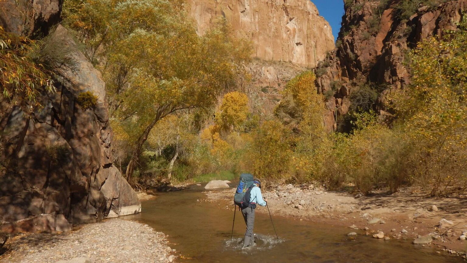 Waterproof socks, water sandals and Gore-Tex gaiters perfect for chilly water crossings (Day1)
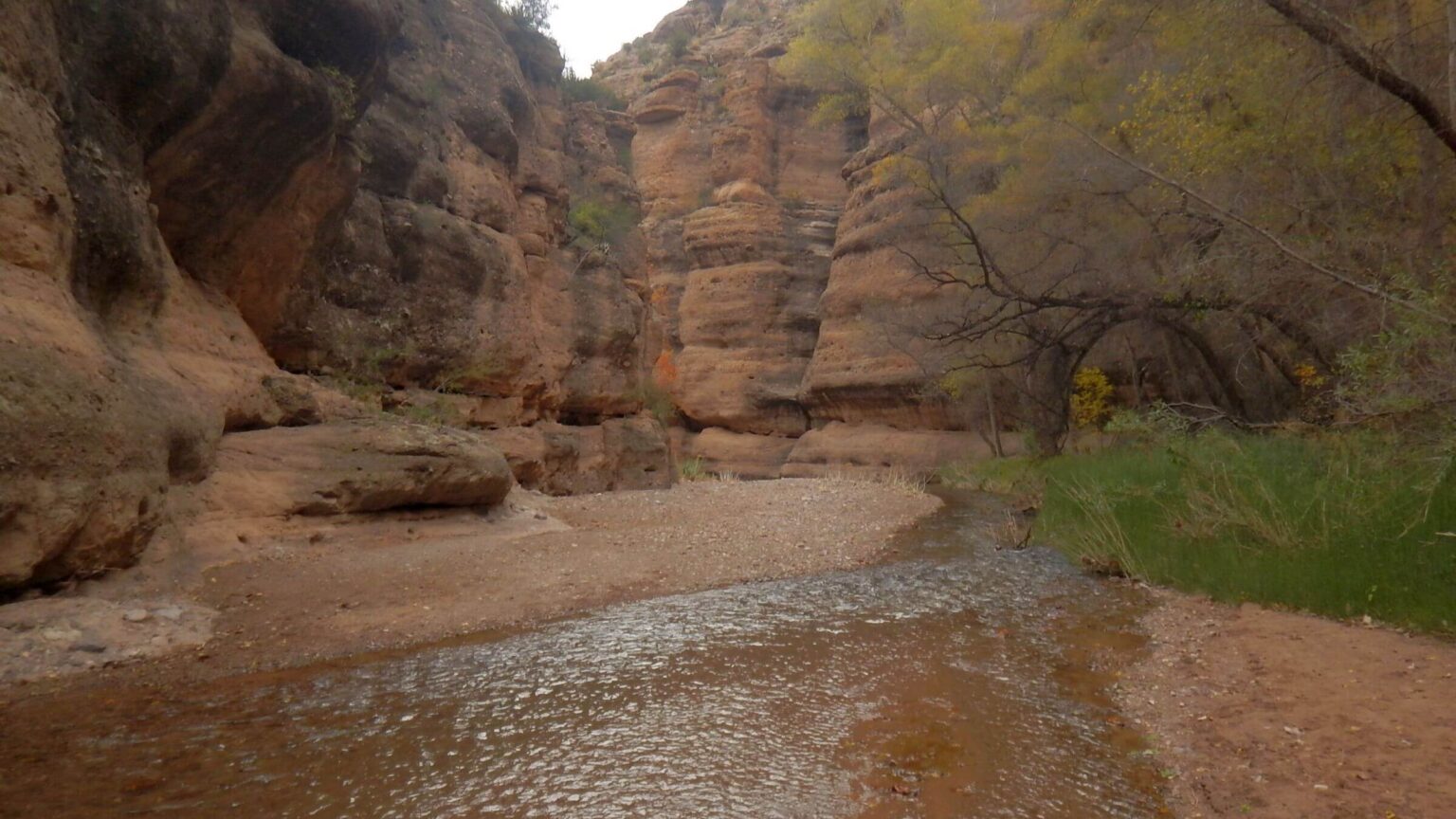 Upper canyon geology changed to buff-and-brown colored conglomerate (Day2)
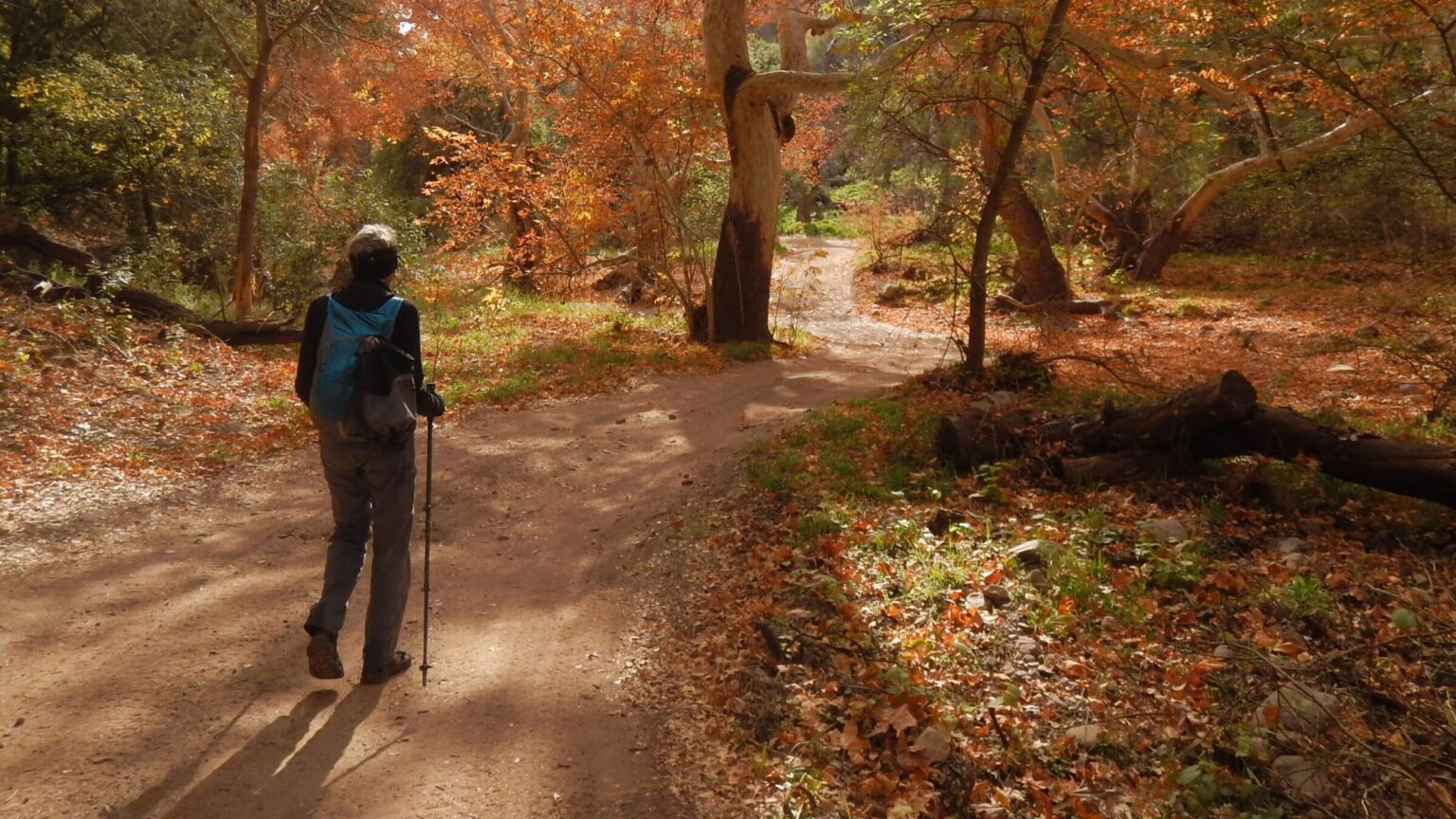 We hiked Turkey Creek Road on eastern wilderness boundary to see ruin (Day2)
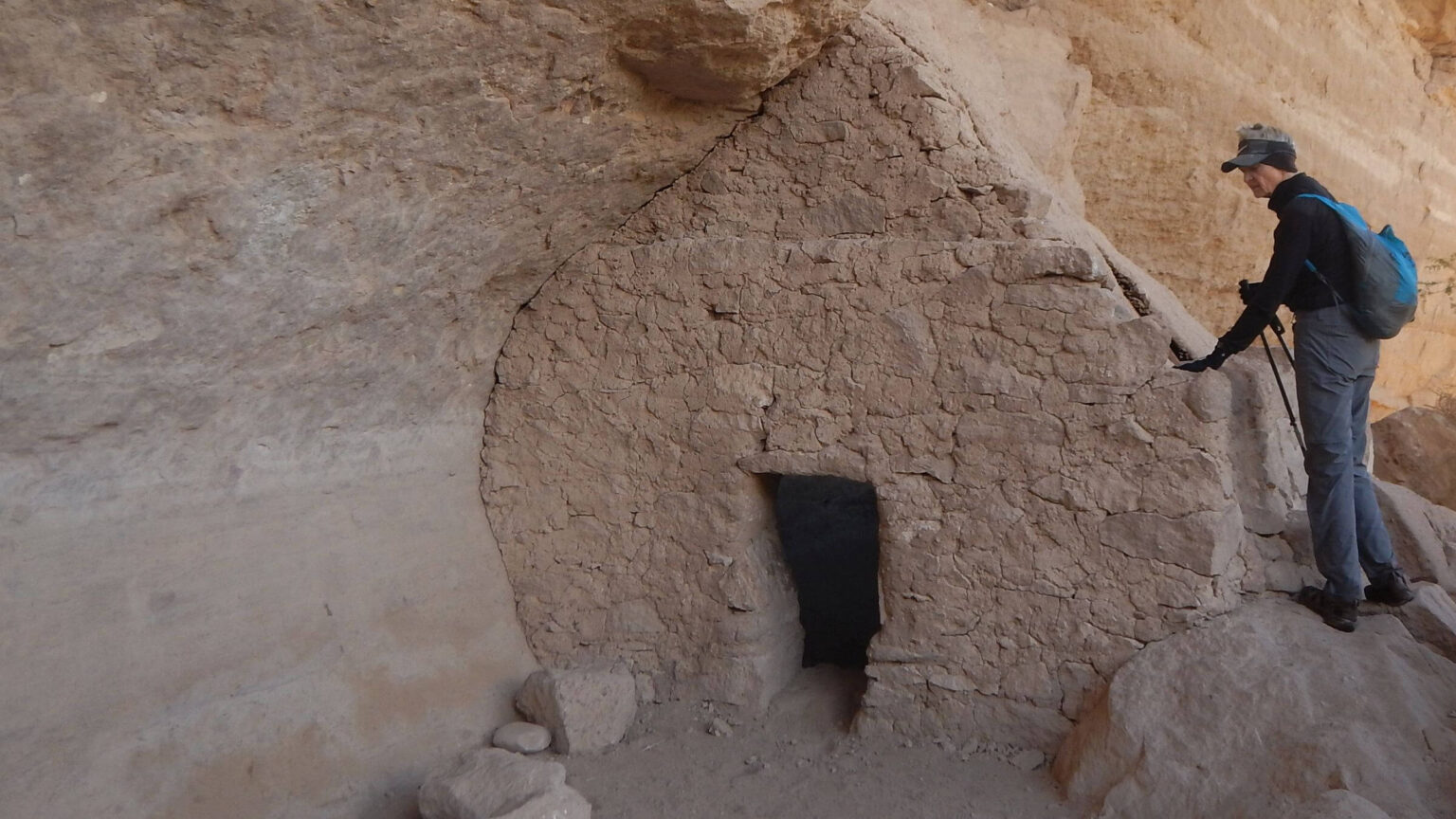 Turkey Creek Ruin: Salado culture dwelling probably about 700 years old (Day2)
Off-Season in Aravaipa Canyon: Fall Colors & Solitude
I was trepidatious about a late November hike in Aravaipa Canyon because it requires crossing the creek many times or even hiking in it. Nice in summer or early fall but chilly later in the year.
Perhaps others agreed: we saw only a few people during our four-day out-and-back hike in this popular canyon—though the reservation site showed almost all 50 “access permits” were filled!
The trip starting Nov. 29 was to celebrate David’s Nov. 28 birthday. One reason for the off-season start was Bureau of Land Management (BLM) limits on entry permits for both backpackers and day hikers. In spring, summer, and fall, those permits are booked months ahead. When David looked into permits in September; first available were late November.
I don’t like being cold; one reason we leave our Idaho mountain residence in October to spend the winter in Tucson! David bought Sealskinz waterproof socks to wear with our KEEN water sandals and Gore-Tex gaiters.
Driving to West Trailhead (off Oracle Highway) past privately owned ranches, we noticed a bonus ahead: masses of golden cottonwood trees along the river. Two SUVs were parked at the trailhead. We came in West Trailhead 70 miles from Tucson mostly on SR-77 and 12 miles dirt road.
We wore two upper layers—turtleneck and shirt—starting at cold, breezy trailhead overlooking the Aravaipa valley. We dropped into the canyon on steep eroded trail and donned water gear for the first crossing. It went fine. Wool and water-repellant Sealskinz socks kept feet toasty and Gore-Tex gators prevented mid-calf water from contact with legs and ankles.
With no wind in the canyon and warming sun, we were soon down to cotton shirts; I rolled up sleeves to my elbows. Feet remained cozy despite many crossings, and Sealskinz socks did not cause blisters. My fears of a cold, wet trip appeared unfounded. However, I still got to camp that night soaked and freezing!
Slosh Through Riparian Paradise Ends Abruptly
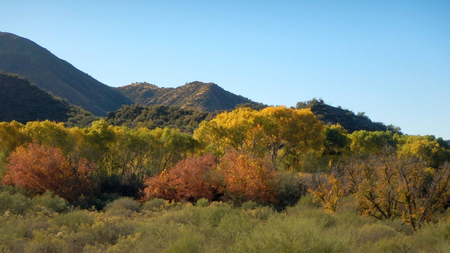
As late morning sun warmed the canyon, hike up the creek was pleasant—although slow. We crossed the creek many times; in narrow sections we sloshed down the channel with steep cliffs on either side.Aravaipa Canyon Wilderness is a 19,700-acre preserve along Aravaipa Creek, a 10-mile gorge in the Galiuro Mountains. Aravaipa is a perennial stream through desert fed by springs, seeps, and tributary streams from Galiuro, Pinaleno, and Santa Teresa mountains. Lush grass and hardwood trees grace the creek; Saguaro cactus are visible on hillsides.
Hikers traverse the canyon one-way from East or West trailheads, which requires either a pickup or “car switch” driving more than 200 miles; or hike out-and-back from either end. High-clearance vehicle ok for 12 miles of dirt road to West Trailhead. East Trailhead north of Fort Grant and Wilcox—150 miles from Tucson—reputedly requires heavy-duty off-road vehicle.
No maintained trail but many “social trails” created by hikers on the banks. Narrow areas require frequent creek crossings and sometimes hiking in water. In cooler temperatures, water shoes and water-repellant socks are recommended.
Bureau of Land Management (BLM) manages wilderness with limited access of 50 visitors per day with three-day stay limit (30 allowed from West Trailhead and 20 from East) but does little else for visitors. Trees or brush blocking routes have led to multiple trails in some areas.
Solitude was our experience even in this popular wilderness. We encountered fewer than 25 people in about seven groups over three days. Apparently, many of the 50 people permitted either did not show up or were ill-prepared and deterred by cold water. We went in late November (first available permit opening), months in advance, and got two of the last permits.
Flash flooding is a concern in Arizona canyons. We had a favorable weather forecast and low water flow from check with U.S. Geological Survey water gauging station in lower Aravaipa Creek. Just under half-foot water flow for our trip which jumped to four feet three days later when a storm passed through.
Visit statistics: 3 days, 28 miles at 2.1 miles per hour, with 150 feet average elevation change per mile.
Go to map below for more information on trailheads, daily routes, mileages, elevation changes, and photos. (Click on white box in upper-right corner to expand map and show legend with NAVIGATION INSTRUCTIONS.)
show more
Hikers had forged “social trails” along sandbars and benches, although willows or other vegetation often blocked routes (forcing reroutes and sometimes crawling over downed logs).
Glorious golden cottonwood, walnut, and ash trees graced the canyon; farther up, we saw more sycamore clothed in large lobed red-brown leaves (resembling a hand with rounded fingers).
We met a few backpackers—most wearing regular hiking boots with long pants rolled up. We passed two tents in a grassy area with backpacks and gear strewn around. Later we met the tent owners lounging in the sun, done hiking for the day.
We also stopped early—but not because we planned to.
We had taken a “social trail” up a side drainage paralleling the creek. It came to a large mud hole left from summer rains. David took a step, and sinking shoes alerted him of possible quicksand. He carefully skirted the hole, thrashing through drooping willow limbs. I followed, but springy branches knocked me right into the hole, burying my pack in mud with me attached!
David rushed to the rescue and pulled me out but broke one of my hiking poles in the process. (In retrospect, he said he should have surveyed situation, moved my hiking poles, taken a drama photo, and then rescued me—but he was worried about quicksand.) He held up my muddy pack and I wriggled out. We clambered over a bank and through trees to the creek. I was muddy from head to toe, so I pretty much sat in the creek splashing water all over myself. I walked up the hillside and perched on a rock in fading sunlight. David retrieved my backpack and brought it to me.
Fortunately, we enclose backpack contents in plastic bags in case of rain, so my evening wear of turtleneck, wool shirt, heavy wool socks, down booties, and stocking cap were dry. I slipped them on and added rain pants (as I had not brought a change of long pants for the short trip). We unloaded my pack and David took it to the creek, with my muddy hiking clothes, for a good washing. After hanging up my wet clothes, he headed up the river bench into the leafless mesquite forest above green grass carpet to find a campsite.
Our plans of hiking another two miles to Deer Creek—a popular campsite—were thwarted. But mesquite grove with big-limb trees to hang my pack, clothes, and “bear” bag would be fine base for next day out-and-back.
My feet stayed warm in the Sealskinz all day, but I neglected to warm them up again before pulling on wool socks and down booties. During dinner preparation, eating, and cleanup, my feet were chilled. I learned that down booties do little good unless feet warm to begin with!
Day Hike Up Canyon: Easier Trails, Marauding Bear Reports
Upper canyon section was broader and easier to hike with good social trails. We passed two camps in lush green grass in Deer Creek area: four people sat around looking cold; a quarter-mile later, three guys with small fire on far side of creek. A couple day-hiking sloshed across the creek to us. At Turkey Creek (1.5-mile jeep road drive from East Trailhead), we saw a few vehicles. We hiked Turkey Creek Road to advertised cliff dwellings, sometimes hopping rocks where the intermittent creek crossed the road.Turkey Creek cliff dwelling was underwhelming compared to other backcountry experiences (see visit to Grand Gulch WSA in Utah) but nicely marked and protected by the BLM; it made a good three-mile loop.
Back at Turkey Creek parking, campers with a fire we saw at Deer Creek were back from an overnight; they said a bear had harassed their camp. We also met the day hikers returning; one lives on Aravaipa Road and hikes the canyon regularly.
The other Deer Creek campers had made a base camp for side canyon visits. One saw 12 coatimundi—raccoon relative with long snout and long, slender tail—that day above Hell Hole Canyon. Other unwelcome wildlife visited: the day before a bear had raided their camp, “tore up my tent and stole my camp shoes,” one of the women said.
Just after Deer Creek camp we noticed a big hole in the rock wall like an arch before a canyon bend. Taking a slightly different route, we found two side canyons with running creeks.
Almost back to camp, we met a man wearing waders with a big tripod over his shoulder. He wondered how far back to Turkey Creek parking. Two or three hours! It was almost sunset, and we did not envy him sloshing along the creek in the dark.
Our camp, off the creek in the mesquite, was undisturbed when we got back. Perhaps my mud hole disaster and early stop was fortuitous—the bear knew about popular Deer Creek camp but not ours.
This time I kept my Sealzskin socks on for camp and feet remained warm!
Our hike out was uneventful. We met a few day hikers. We found better routes on the way back, moved a bit faster, and crossed another side canyon with running water. The spring we had noted on the way in was warm! David, moving ahead, saw three deer that I missed.
We both saw the young Hereford heifer lying on the bank, just after last creek crossing. She did not look well. (I reported her to the BLM range conservationist.) Not the wildlife sighting you want in a wilderness, but a reminder of Aravaipa’s very recent history.
Aravaipa’s Human History
Aravaipa is thought to be an Apache word meaning “laughing waters.” Archaeological history showed the Hohokam, Mogollon, and Salado Indians lived there, hunting game, and growing a variety of crops until they mysteriously left their cliff dwellings in the 14th century. About that time, Apache Indians migrated to Arizona from the north, and by 1700s they had settled in Southeast Arizona mountains. One band lived near Aravaipa Creek.The Apaches sparred with Spanish explorers and other local tribes. In 1854, after the U.S. “bought” southern Arizona and part of New Mexico from Mexico in the Gadsden Purchase, miners and settlers poured into the area. Raids and skirmishes ensued between the people already living on the lands and the so-called “new” landowners.
Commander of Fort Grant near the canyon created a refuge for nearly 500 Apache Indians along Aravaipa Creek about five miles east of the fort. They began cutting hay for camp horses and harvesting barley from nearby farms.
A group of Tucson residents blamed all settlers’ Indian problems on the Fort Grant Apaches. In 1871, white vigilantes assisted by Tohono O’odham Indians and Mexicans attacked the camp while most men were away hunting. They killed 144 people, mostly women and children, and 29 children were sold into slavery in Mexico.
The military and newspapers in Eastern states decried the massacre; President Grant threatened the state of Arizona with martial law unless a trial was held. A Tucson grand jury indicted 100 of the assailants on 108 counts of murder but found them not guilty. As pioneer families settled the area, Apaches never regained much of their ancestral lands.
In the 1870s, settlers from Mexico and Anglo-American farmers, ranchers and miners arrived in the area. According to a 1991 ethnoecological survey, during the early 20th century, almost 1,000 people were scattered here, supporting farm villages on each end of the canyon, with five mining camps, large ranches, irrigated farmland, homesteads, Angora goat camps, and mining prospects. The survey, developed for the administering BLM, describes ecological impact from 80 years of settlement. Most mining ended by the 1950s. Abandoned corrals, mining prospects, and old roads/trails remain. (Google “BLM 1991 ethnoecological survey for Aravaipa Canyon” if interested in 450-page report.)
Early ranchers knew little of desert grazing practices and brought in large livestock herds to serve the military. Overgrazing the land reduced native grasses and increased non-native species and bare ground. Damage from more than 50,000 cattle was described as early as 1901.
Aravaipa Protection & Resources
Taylor Grazing Act of 1934 replaced open grazing with more fencing, rest-rotation of pastures, and some attempts to match cattle numbers to land capacity. As human settlement in Aravaipa declined, a growing urban population in Arizona lobbied for more protection. Aravaipa was made a primitive area in 1969 by Secretary of Interior, and wilderness in 1984, with additional acreage added in 1990, all administered by the BLM. The Nature Conservancy (TNC) bought a ranch outside Aravaipa in 1971 and now has two preserves on east and west end of canyon encompassing 9000 acres.BLM, TNC, and other partners have worked on restoration. BLM removed all cattle from canyon bottoms, although it allows some grazing on tablelands above. Removing cattle and reducing human use has allowed natural revegetation; prescribed burns on tablelands have assisted return of native grasses. Invasive salt cedar is sometimes removed by hand.
Arizona Game & Fish has reintroduced bighorn sheep with current herd of about 160. U.S. Bureau of Reclamation is working on plans for a fish barrier on private land at the San Pedro end of the creek, to exclude non-native fish from entering the canyon waters.
Aravaipa has a high level of water quality and supports a large native desert population, including the federally protected spike dace and loach minnow. Hundreds of bird species and 44 mammals are seen in the canyon. We had hoped to see the coatimundi but only heard about sightings from other backpackers. We saw deer, squirrels, frogs, and birds.
Management Suggestions For Resource Protection & Visitor Enjoyment
We have noticed that natural resource agencies seem to operate on assumption that “wilderness” means no management activity. However, some light work in the wilderness would better protect resources and enhance public “use and enjoyment,” which according to Wilderness Act of 1964, is the main purpose for establishing wilderness.BLM has apparently done some work to restore and improve natural resources in Aravaipa but does little for visitor management, which would indirectly reduce trammeling and help protect wilderness. Instead of just limiting visitor numbers, BLM could expand hiking options by providing some loops. Google Earth imagery indicates it might be plausible to connect some old abandoned upland roads with side canyon routes.
Camp overcrowding could be reduced by shoveling and clipping out a few more campsites. Adding bear boxes in popular areas could help, as tree limbs for hanging bear bags are limited. (We camped in an obscure area with a good limb for hanging food and were not bothered by bears. But at least two camps we hiked through in a popular camp area had bear issues.)
Finally, adding cairns and some light tree/brush cutting for best route in main canyon seems a must—to channel hikers onto one path and prevent further resource destruction from multiple routes. The cows and cow paths are gone, but no need to replace them with hiker spaghetti trails.
show less
Google Map
(Click upper-right box above map to “view larger map” and see legend including NAVIGATION INSTRUCTIONS; expand/contract legend by clicking right arrow down/up.)