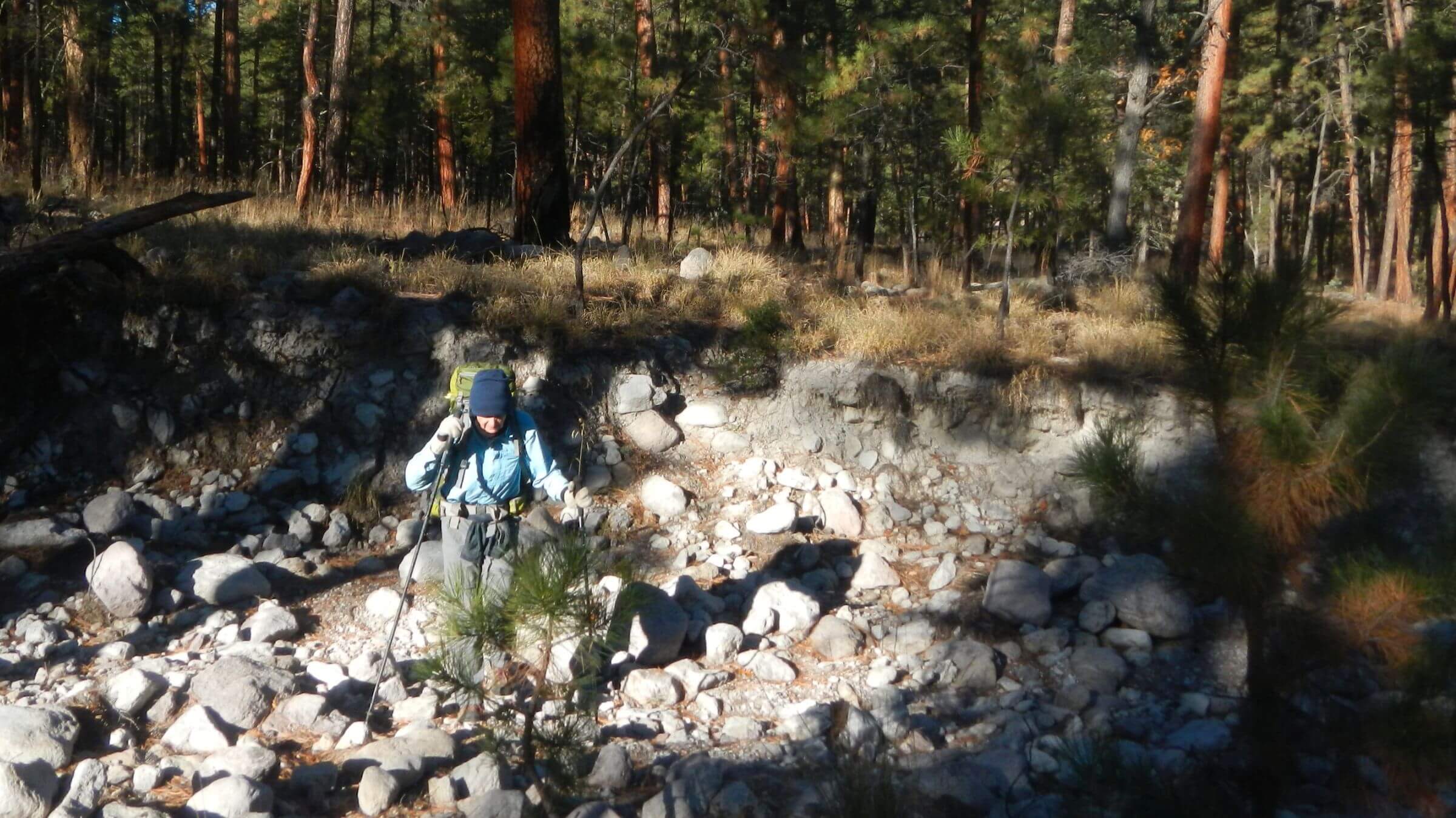
I recently made my 10th visit to the Gila Wilderness in southwestern New Mexico—the nation’s oldest wilderness lying along a vast ridge and valley landscape with forests of ponderosa pine and oak-pinyon-juniper on ridges above Middle and West forks of the Gila River. It was a nice trip—but only because we avoided favorite areas where trails are now impassable. I posted our visit as “The Trip We Didn’t Do.”
The Gila wilderness is oldest in the country—its centennial will be 2024. Famous conservationist Aldo Leopold first came to this area in the early 1900s, formed many of his ideas about wild lands and ecology here, and in the 1920s lobbied Forest Service superiors to name Gila a wilderness. Regional Forester Frank Pooler classified it as Gila Wilderness in 1924—40 years before the Wilderness Act of 1964.
The original area was 755,000 acres and also included the west half of what is now Aldo Leopold Wilderness Area.
In 1964 the Wilderness Act named most of the Gila among wilderness areas in the U.S. The New Mexico Wilderness Act of 1980 increased Gila Wilderness acreage to 558,064 acres and created a 202,000-acre Aldo Leopold Wilderness Area to the east.
The two wilderness areas range in elevation from 5000 to nearly 11,000 feet, including rich riparian habitat and the some of the largest remaining stands of old-growth pine in the world—highly valued for logging.
As University of Arizona students in the 1970s, we often visited the Gila—only four hours from Tucson with 700 miles of trails. A Forest Service planimetric map (one-half inch to mile scale) was all we used as trails were easy to follow. Some trails were built by early sheep and ranching interests, others to access fire lookouts; some probably were rebuilt to gentle grades for stock use by the Forest Service or Civilian Conservation Corps which had 17 camps on or near the Gila National Forest from 1933-42.
Patrolling and maintaining trails was part of Forest Service work in the early to mid-1900s. Trails accessed fire lookouts on mountain peaks staffed every summer, along with backcountry guard stations which served as launch point for summer work such as patrols, fire suppression, marking boundaries, building fence and checking cattle numbers and range condition.
Fairly stable forest vegetation and temperature ranges throughout the 1900s (unlike recent trends towards higher temperatures) helped. For example, the mixed conifer forests in higher elevations and ponderosa in mid elevations kept needle blanketed paths mostly intact with little maintenance needed other than cutting out an occasional down tree.
The past 10–15 years of big fires has magnified trail maintenance needs, which continue many years after fire. But federal funding and presence is going in the opposite direction.
An oddity of federal fire management funding is almost unlimited fire-fighting budgets through national administration for large fires but post fire administration returns to local administration where funding is much more limited. Gila Wilderness is case in point. Some $23 million was spent to combat the Whitewater Baldy Complex Fire and another $10-11.5 million on restoration efforts. Some funding was available for trail work for five years after the fire, but post-fire trail needs continued after this period.
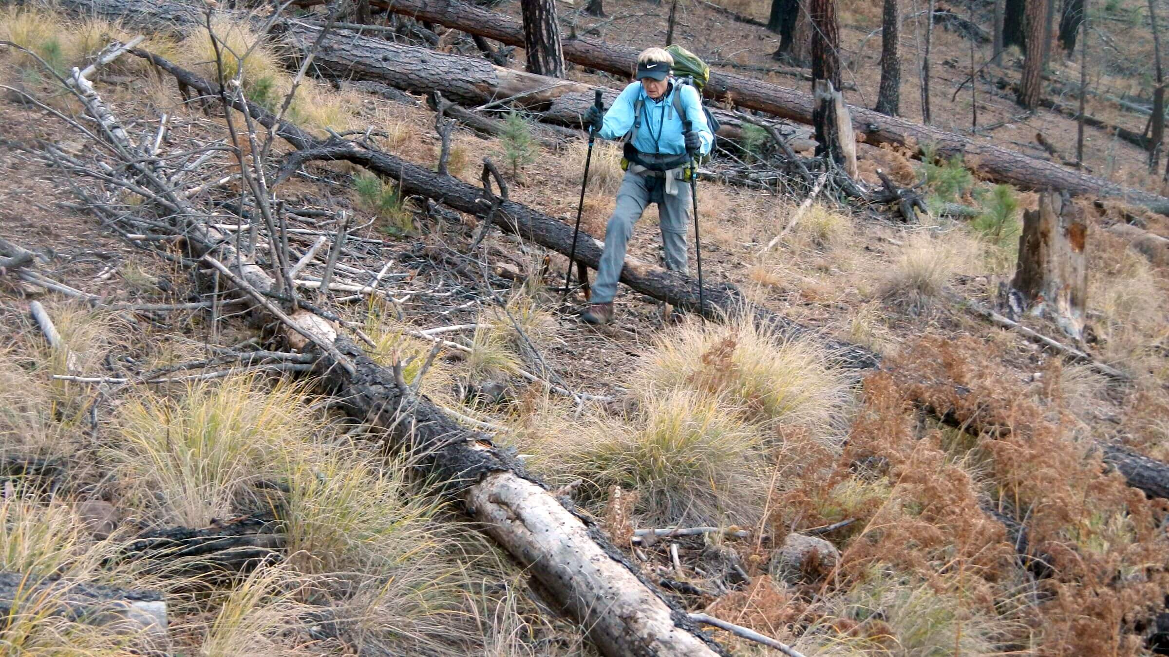
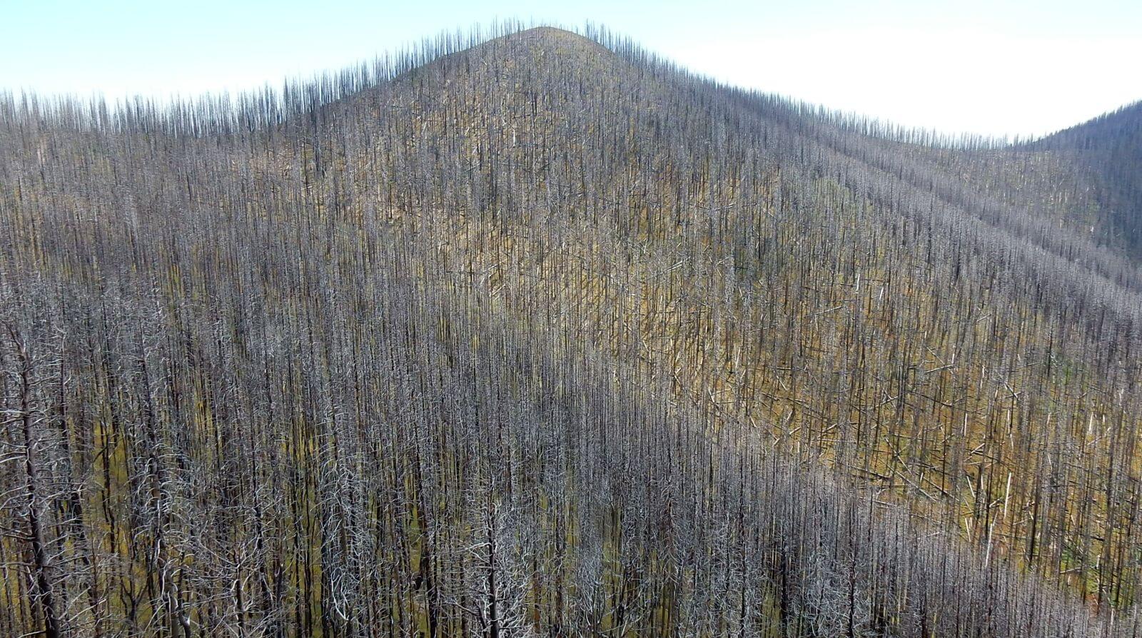
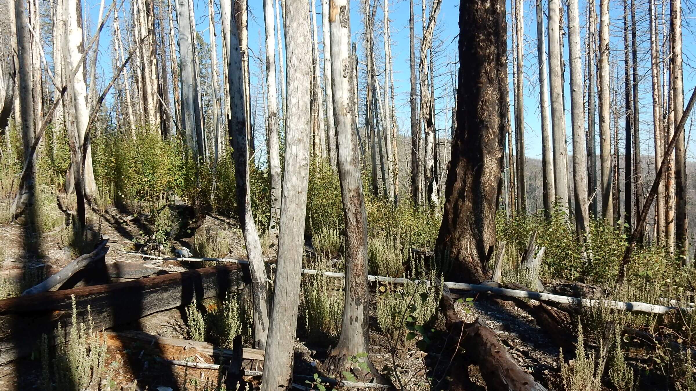
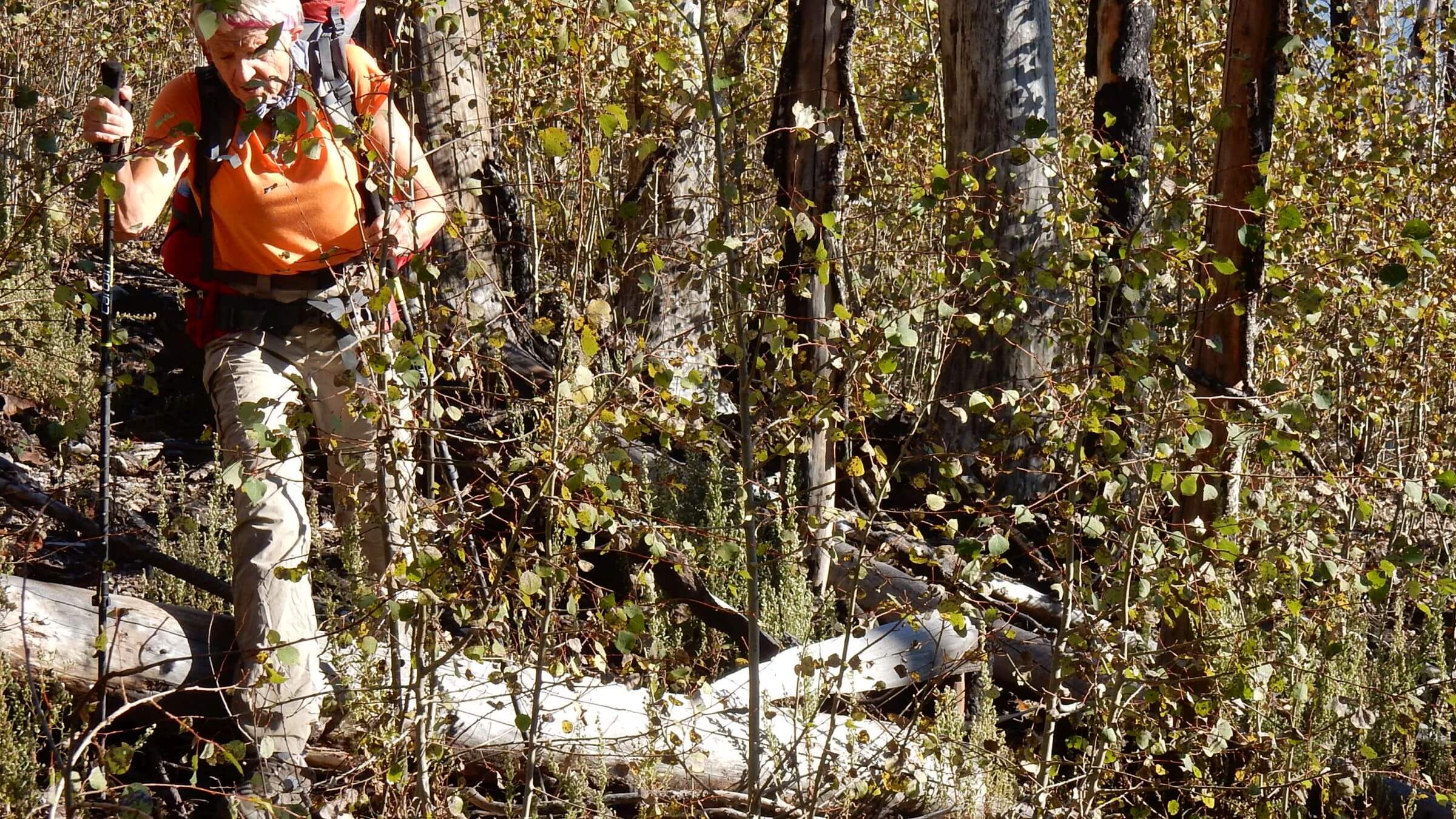
Much of the Gila trail system was impacted by the fire and results such as downed logs, New Mexican locust and other fire-stimulated vegetation, and post-fire floods that washed out creek trails. Most trails west of the Mogollon Crest are impassable and trails up to the Crest damaged.
On the Gila and other southwestern forests that we have visited over the years, field-going trail champions are retiring. John Kramer, wilderness manager for most of the Gila and the Aldo Leopold, kept a seasonal trail crew working in the wilderness for decades with proactive grantsmanship. He got grants from entities such as Coca-Cola interested in clean water by arguing that repairing trails reduced watershed erosion. But Kramer has retired and Gila National Forest officials decided to transition to a forest-wide trails crew not dedicated to wilderness. A local non-profit led by trails professional Melissa Green has assumed as much wilderness trail maintenance and restoration as possible, working with partner groups and volunteers.
On a “moonscape” crawl in the Mogollons three years after the big fire, we learned the hard way you can no longer waltz into the Gila with a simple map and expect a serene hike. Hike planning now requires phone calls with locals, GPS work and consultation with Google Earth imagery. It is particularly annoying that topographic maps—basis for GPS and most new map editions—have not been field checked by the U.S. Geographical Service developers since the 1990s; so no trail maps are current after large fires. Heart of the Gila is a rare resource—keeping a running inventory of “trails cleared” and “trails not recommended” for Gila Wilderness.
Other southwestern wilderness such as Chiricahua, Mount Wrightson, Miller Peak, Mazatzal and Sierra Ancha exhibit similar problems. Large fires from 2000-2013 demolished most high-country forest, contour and streamside trails. Some fire ecologists think that stand replacing fire every few centuries may be the natural regime for mixed conifer. While natural post-fire recovery proceeds on Gila Wilderness parks and forests, the trails will not recover naturally.
Meanwhile, Forest Service officials are much more desk-bound by appeals, process, and administrative work. Only commercial outfitters, hunters and equestrian groups ride the trails; most backcountry Forest Service guard stations are mothballed, leaving the agency with little incentive to keep trails open for its work.
I have met many wilderness “heroes”—whether agency field people, rangers or volunteers—scrabbling together volunteer projects and a little contract work to keep priority trails open. But as one Arizona trail coordinator told me, “It’s a moving target.” Moving downwards.
Fewer trails also add to wilderness overuse in areas where trails and information are good—something we call the “trails-solitude inverse.” It would be good stewardship to retain our vast network of legacy trails to disperse people and ensure the solitude envisioned in the Wilderness Act. This may not be an issue unless you hike or ride in the wilderness. But if you have glided along legacy trails in western wilderness, then return to find them unusable, you may share my concern.
“A well maintained well distributed trail system is essential to protect the wilderness,” noted Bill Cunningham, a lifelong wilderness advocate, former Gila backpacking guide, and coauthor of a 2017 post-fire Gila hiking guide. “Otherwise you will have concentration of use in hot spots.”
Most wilderness advocacy goes towards protecting wilderness. Trail loss might seem like a minor issue given other threats to public lands. But public access to wilderness is diminishing from loss of legacy trails damaged by climate change related events, while management agencies have less incentive and funding to keep trails open. I applaud the volunteer stewardship groups stepping into the gap, but can they do all needed restoration?
The Trails Stewardship Act of 2016 allows credits for trail work to outfitters, expands volunteer partnerships and allows off-duty federal fire crews to work on trail maintenance. Pay incentives (usually hazard pay and extended hours for staff on a fire) may be lacking and some crews may balk at using traditional tools like crosscut saws required by Forest Service in wilderness. But it’s a start. (By the way, we saw chainsaw cuts on some trees in the Gila Wilderness after the Mogollon-Baldy Complex fire indicating possible exemption to use chainsaws in wilderness. Perhaps such an exemption could be extended to post-fire trail rehabilitation in some situations.)
The Wilderness Act of 1964 states that wilderness areas are to be designated and managed “unimpaired” for “future public use and enjoyment.” If the public cannot “use and enjoy” wilderness, or, by default, overuses a few known areas, we miss the social purpose for wilderness and deprive the next generations of wilderness users.
Thank you, Cindy Chojancky, for this article. You are so right. My husband and I have backpacked all over the Gila and the Aldo Leopold Wildernesses since 1993 and have seen the devastation to forest and trails caused by these massive fires. We live in Silver City so this is our back yard. We considerer ourselves fortunate that we passed through the old growth Doug Fir forests that once crowned the mountain ridges. Trails we once backpacked along the crest of the Mogollon Mountains and the Black Range are gone now or impassable. It’s hard to navigate our way when we have to cross country through a pick-up-sticks of downed aspen and pine trees in a burn area. Over the years trail maintenance has been grossly lacking. We once had wonderful trails in the Gila NF. No more. It’s only by the work of a few and only on a few main trails do we have the quality we once had forest wide. Thanks to Heart of the Gila there is a pro-active movement to bring back the trails here. I hope your article reaches many people who once hiked the Gila and will bring them back to experience and contribute to effort to save our tails in this remarkable forest. We are now in our 70’s and no longer backpack. Trail work is difficult for us. I hope the new generations will find the time and passion to carry on this work for themselves and the future, for the love of the forest and being there.
Thank you Jackie for a very knowledgeable response. I totally agree on Heart of the Gila which is so well named. Melissa Green is a Force and I hope she and Oliver (with many volunteers) continue to keep the public’s legacy trails open for many more years. Maybe our latest national crisis will turn more hearts back to the wilderness, our wonderful gift. CindyC
Hi Jackie,
I’m trying to get settled down enough to make some comments on the Forest Service Revision. (I think it is cumbersome on the computer, but I have to adapt.). I will definitely consider these points. I’m too new to remember what it used to be like.
Thanks Chris for your comment. I notice you responded to Jackie who was responding to my blog (CindyC) on the Gila wilderness losing its legacy and sort of agreeing. Glad you are commenting on Gila Forest Plan revision. I believe deadline for comments is April 16. CindyC
Packed in the Gila Wilderness 40 years, worked there in fire towers, dearly, dearly love the place. But your article is spot on – it’s largely unrecognizable. Try going from Iron Creek to Turkey feather Pass, good luck!
I began hiking about age 58 in order to separate myself from the thundering hordes that I was finding when I was car camping. Since I live in Idaho that is where I have done most of my hiking and naturally what I am most familiar with. At about age 67 or so, I started hiking with goats as carrying large loads on my back was getting difficult. I also began to look around to find somewhere I could go in the winter with the goats and still be able to hike. I settled on Glenwood as the Double T Homestead allowed me to bring my boys and spend time doing what I couldn’t do in Idaho, hike. Then there was a hiatus while I got out of debt and during that couldn’t go anywhere. This Feb, I returned to the Double T, and tried to spend the whole month exploring that area of the Gila. It wasn’t an ideal year as I got stymied by high water in a couple of locales. The Gila, and San Francisco rivers were both running too high to chance crossing. I was saddened to see the condition of the trails in the Glenwood area. The only one that was still in good condition was the Gold dust trail which I was on a couple or three times. The Little Dry Creek trail was simply an endurance test. The furthest I made it in two tries was 2.6 mi. The further I got, the worse it got. Since I was day hiking, I had to be careful how deep I penetrated as I had to go all the way back out each time. I was especially disappointed that there was always a sign at the beginning of the trail that said, ‘Trail Not Maintained’. In Idaho, there is a trails group that is doing a lot of trail maintenance every summer, privately funded. It is clear that something like that needs to happen in the Gila. If you go to my website you can see where my travels took me. I intend to relocate to the Glenwood-Pleasanton area in the near future, so I have a stake in helping things improve.
Thanks Larry for your observations. We reside in Hailey Idaho so aware of trail situation there–although parts of the Sawtooth and Frank Church River of No Return Wilderness have serious trail maintenance problems despite good volunteer system. You are finding trails on Glenwood RD (westside of Gila Wilderness) particularly bad because post-fire flooding after Whitewater Baldy Complex Fire os 2012 pretty much decimated the Whitewater Creek/ South Whitewater Creek trail system. And trail people I talk to say it will be 10 years before it is worthwhile working on some westside areas when the floods/mudflows/ deadfall subside. That said, Heart of the Gila has an excellent trails program and you should get in touch with them. Website Also there’s excellent guidebook “Hiking New Mexico’s Gila Wilderness”just updated 2018 that offers some good loops/routes on west side working around fire damage problem. Glenwood is great area. They had fabulous system before the fire. I went to school at University of Arizona so we almost always came in from the Catwalk. Happy Trails! CindyC
Well said. We’re backpackers from Tucson who have made 3 trips to the Gila. We had no idea what we would be walking through in 2016 to do Sandy trailhead to butterfly saddle across the crest to Mogollon baldy. While the trail had been maintained, I had never experienced that kind of devastation across all our southern AZ travels. I wish I had seen it before the fire (although that would be hard and depressing to really understand what has been lost) I hope we see a change in policy especially in light of the renewed interest in the backcountry. Here’s the video from the trip.
https://vimeo.com/181722636
and a blog about it: http://yourcameraisnotbigenough.blogspot.com/2016/09/high-and-dry-traversing-highcountry-of.html?m=1
I came across your blog looking up some trips now with our 15 month old baby. We try to stick to well maintained easy traveling trails. It is unique to be planning a trip with a map and the list of maintained trails and the list of non maintained trails.
Hi Lori. Thanks! The music on your vimeo is lovely and I like your blog! We live in Phoenix part time (Idaho the rest) but are poised to move to Tucson as soon as we find the place. David & I met at UA Ramblers. I can relate to hiking with a baby. We raised our daughter hiking in the High Uintas. I remember her happily negotiating a mile of bog bridge as a toddler! We used to take turns packing backpacks while the other either hiked with her or carried her in kid carrier. Good times! If you want S. AZ version of fire devastation, check out high crest of the Chiricahuas (still a pretty easy hike from Rustler Park) or Mt. Wrightson (although some nice old growth on the Baldy Trail )! Yes the Gila was something like paradise in the old days. We recently visited its neighbor wilderness the Aldo Leopold and the high crest is almost completely burned! Wish we had gone there when we hiked the Gila many years ago.
Excellent article! I lived in NM (Albuquerque) from 1997 to 2002 and never made it down to the Gila Wilderness. Fast forward close to 20 years, I now live in Northern MI, and I finally made it!
Did a 50 mile clockwise loop of the West Fork, overland north, Middle Fork, and Little Bear Canyon. Years ago I did alot of backpacking in the Pecos Wilderness, but I think the GW is the best place I’ve been to in NM.
It’s called wilderness Einstein, and it’s been off limits to the handicap population since day one. Welcome aboard.
Not sure what you mean, friend. Einstein? Meant to be insulting? Actually some of the population with disabilities do amazing things in wilderness. In the White Mountains of New Hampshire (mostly wilderness I believe) I saw amazing video of an advocacy group where folks ascend the Whites in specially designed self-propelled wheelchairs assisted by a few friends. But yeah, the wilderness will continue becoming less accessible for all at current rate of trail maintenance along with fire impacts which was point of the blog.
I lived in Silver city in 82-82. I packed from Snow lake down the middle fork of the Gila and up that trail from the cliff dwelling. I walked up turkey Creek trail and white water (?) Trail. And down Sapillo Creek to the Gila crossed and over to Miller spring, down to turkey Creek trail and north to the trail back to the cliff dwelling. I’m too stoned up for that now, but I’m glad for the memories. Many other day trips to the wilderness too. It’s sad to hear that trails aren’t being kept up. Hopefully people will continue to repair the area trails till maybe the government will see the light. Thanks for the good times in the Gilly
Previous message should have said ” stoved up not as it shows
My career started in trail maintenance for USFS Bob Marshall Wilderness and Selway Bitterroot. I read this with interest. Trails are good. I ascended plenty of trail less ridges on my days off. It was good grunt work. I have to take your word for the …in effect.. neglect that has ensued.
Not sure if readers have read the recent papers and press that suggest this was once historic jaguar range and could be once again.
Thanks for informative article. Wild country, natural processes, wind, stars, and pines, all good.
Thanks John. Love to hear your stories of trail work and adventure in the West sometime. Sure wish the FS still had professional trail crews. Very few these days. In the Southwest region, forests sometimes get grant money and contract with youth conservation groups for the heavy reconstruction work.
No I didn’t know about the jaguar range. If you can point me to references, that would be great. I recall the Arizona Star ran a photo of a young mail jaguar on the Arizona-Mexico border, on Mexico side. Sometime earlier this year.